answer.
Ask question
Login Signup
Ask question
All categories
  • English
  • Mathematics
  • Social Studies
  • Business
  • History
  • Health
  • Geography
  • Biology
  • Physics
  • Chemistry
  • Computers and Technology
  • Arts
  • World Languages
  • Spanish
  • French
  • German
  • Advanced Placement (AP)
  • SAT
  • Medicine
  • Law
  • Engineering
m_a_m_a [10]
2 years ago
4

Which of the arrows on the climate map above is pointing to the Sahel, the semiarid region bordering the Sahara Desert? A. One (

1) B. Two (2) C. Three (3) D. Four (4)

Geography
2 answers:
RideAnS [48]2 years ago
7 0

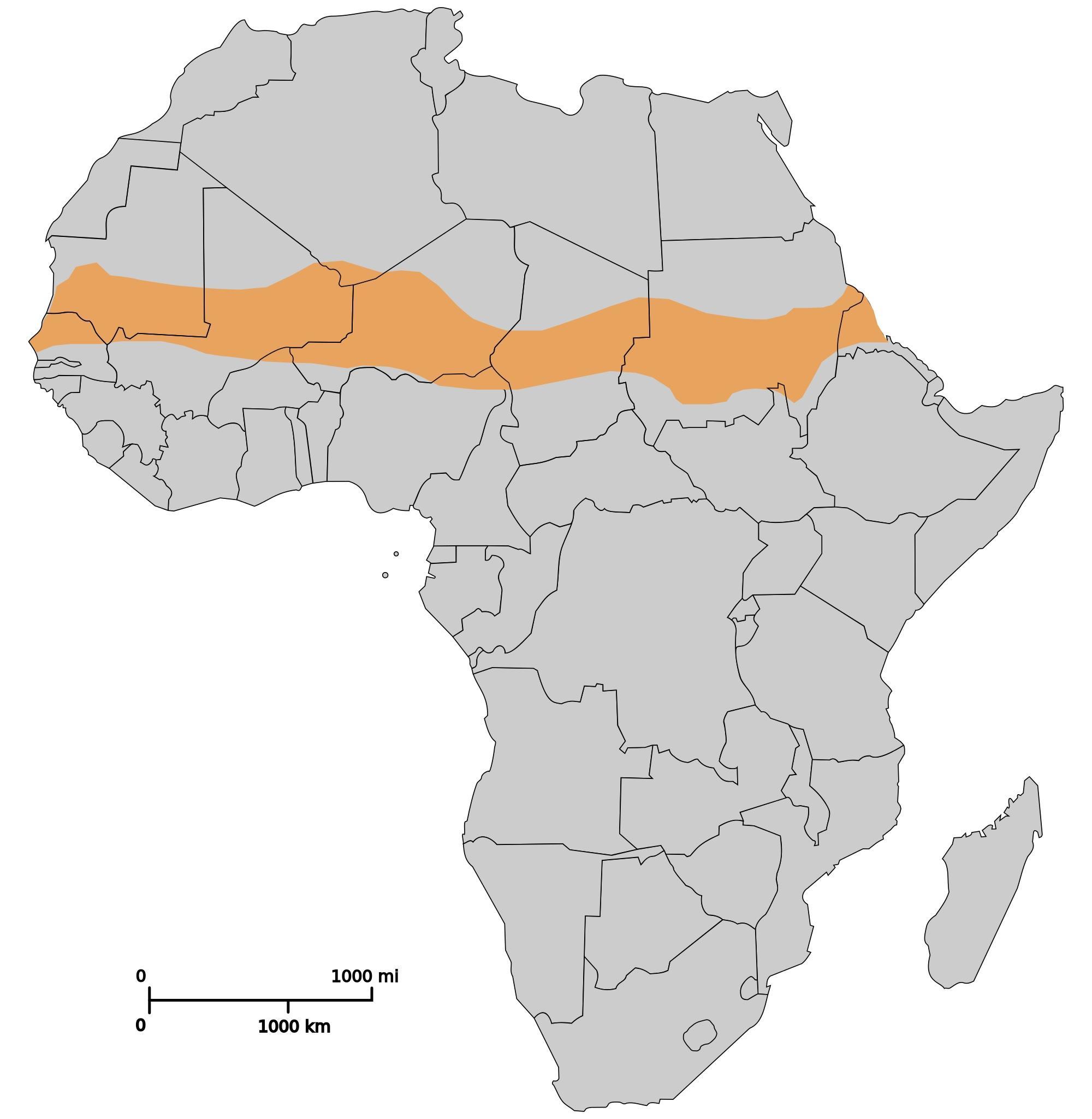
The Sahel is a region in Africa that is located along the southern part of Northern Africa. This region is a natural transitional zone between the deserts on the north and the savanna and tropical forests on the south. The Sahel stretches roughly in an east-west direction, from the shores of the Red Sea to the shores of the Atlantic Ocean.

The climate in this area is semi-arid. The temperatures are hot all year round, the precipitation levels low, though higher than the desert, and it is relatively windy. The landscape is rocky and the vegetation that dominates is of steppe type.

The countries through which the Sahel passes are Senegal, Mauritania, Mali, Burkina Faso, Algeria, Niger, Nigeria, Cameroon, C.A.R., Chad, Sudan, South Sudan, Eritrea, and Ethiopia. These countries are also included in a project for making a forest band in the Sahel so that the desertification is prevented and fought back.

Ira Lisetskai [31]2 years ago
6 0

Answer:

d

Explanation:

You might be interested in
Sort the characteristics based on whether they describe mass wasting, tsunamis, or both.
Anvisha [2.4K]

Answer:

  • 1. It can be triggered by tectonic plate movement.   -    <u>both</u>
  • 2. The name means "harbor wave."   -    <u>tsunamis</u>
  • 3. It’s movement of land triggered by gravity.   -    <u> mass wasting</u>
  • 4. Creep and topple are names for two types of this hazard.   -  <u>mass wasting</u>
  • 5. Scientists use deep ocean assessment and reporting (DART) to warn of this hazard.  -  <u>tsunamis</u>
  • 6. One example is mud flowing down a hill and onto a highway.    
  • <u>mass wasting</u>

Explanation:

  • The characteristics of the tsunamis are related to those associated with the shaking of the ground that is produced by the movement of the tectonic plates from below as in the event of the earthquakes and thus the sudden release of the violent energy create huge killer waves and they can also lead to the mass wasting phenomenon.
  • <u>Hence the process of mass wasting occurs due to the movement of the layers of them is under the flow of the gravity and is a hazard that is associated with the earthquakes.</u>
4 0
2 years ago
Read 2 more answers
Today the Mediterranean Sea lies between Europe and Africa. But the African plate is moving toward the Eurasian plate at a rate
kkurt [141]

Answer:

the ocean levels will decrease do to land increasing caused by dried up magma on the land expanding the lands

Explanation:

I'm high and don't know what I'm talking about

6 0
2 years ago
Northern Hemisphere winters are colder than Northern Hemisphere summers because Northern Hemisphere winters are colder than Nort
antoniya [11.8K]

Answer:

e) both c) and d) above are correct

Explanation:

The equator is an imaginary line running from east to west that divides the earth into the northern hemisphere and southern hemisphere. The northern hemisphere is the half part of the earth that is north of the equator.

During the summer, the light from the sun shines more directly on the Northern Hemisphere.

Also during summer, the period of sunlight is longer than that of the winter.

4 0
1 year ago
If the contour interval of a map were halved, how many contour lines would be needed to show the same increase in elevation? A.
Elena L [17]

The real answer is C. the same number!

5 0
2 years ago
Read 2 more answers
Explain why dry farming was the ancient Mesopotamians' preferred method of farming. What eventually made dry
Ne4ueva [31]

Answer:

little rainfall

Mesopotamians depended on the annual flooding of Tigris and Euphrates rivers

this was similar to the Egyptians

gdghdghggb

4 0
2 years ago
Other questions:
  • Both Pakistan and India have claimed the Kashmir region. This situation has resulted in which of the following consequences?
    12·2 answers
  • You are in a hot air balloon, 200 m above the flat Texas plains. you look out towards the horizon. How far out can you see- that
    8·2 answers
  • How can the relative positions of an aquifer and aquiclude result in the presence of a spring?
    9·1 answer
  • The geotherm is the rate of change of ____________.
    13·1 answer
  • Given the opportunity to manage a government operation intended to educate citizens about endemic diseases, what are two resourc
    10·2 answers
  • Which statement is true?
    9·1 answer
  • Brasília was designed to mimic the shape of what object? View Available Hint(s) Brasília was designed to mimic the shape of what
    15·1 answer
  • Which of the following concepts explains the decision to re-locate market-oriented factories in the United States from the Midwe
    15·1 answer
  • Which prop would be most appropriate on the set of Brighton Beach Memoirs to indicate that the play takes place in 1937? a black
    5·2 answers
  • Which of the following statements about the planet Venus is true? a. its thick nitrogen-oxygen atmosphere acts like a greenhouse
    14·1 answer
Add answer
Login
Not registered? Fast signup
Signup
Login Signup
Ask question!